The Atlas of the United States Printed for the Use of the Blind was published in 1837 for children at the New England Institute for the Education of the Blind in Boston. Without a drop of ink in the book, the text and maps in this extraordinary atlas were embossed heavy paper with letters, lines, and symbols. To the best of our knowledge, this is the first atlas produced for the blind to read without the assistance of a sighted person. Braille was invented by 1825, but was not widely used until later. It represented letters well, but could not represent shapes and cartographic features. Samuel Gridley Howe (1801-1876) was the founder and president of the New England Institute (later known as the Perkins Institute) and produced the atlas with the assistance of John C. Cray and Samuel P. Ruggles. Howe was the husband of Julia Ward Howe, the American abolitionist and author of the U.S. Civil War song "The Battle Hymn of the Republic." He was a champion of people with disabilities and believed that blind youth could be taught geography through maps created with his special paper embossing process. In his introduction to the atlas Howe notes that crude attempts had been made to create maps for the blind, but they used primitive methods of creating relief and required the assistance of a sighted person. He claimed that his new embossing method was superior in all respects. Today, it is difficult to know how successful the atlas was, although there can be little doubt that these maps helped Howe's blind students visualize geography. We do know that 50 copies were made and five survive today, including this one. The atlas includes 24 state maps with a page of text describing each state and the symbols used on the maps. In our scans, we have lit the maps and text pages from one side to create shadows that reveal the embossing.
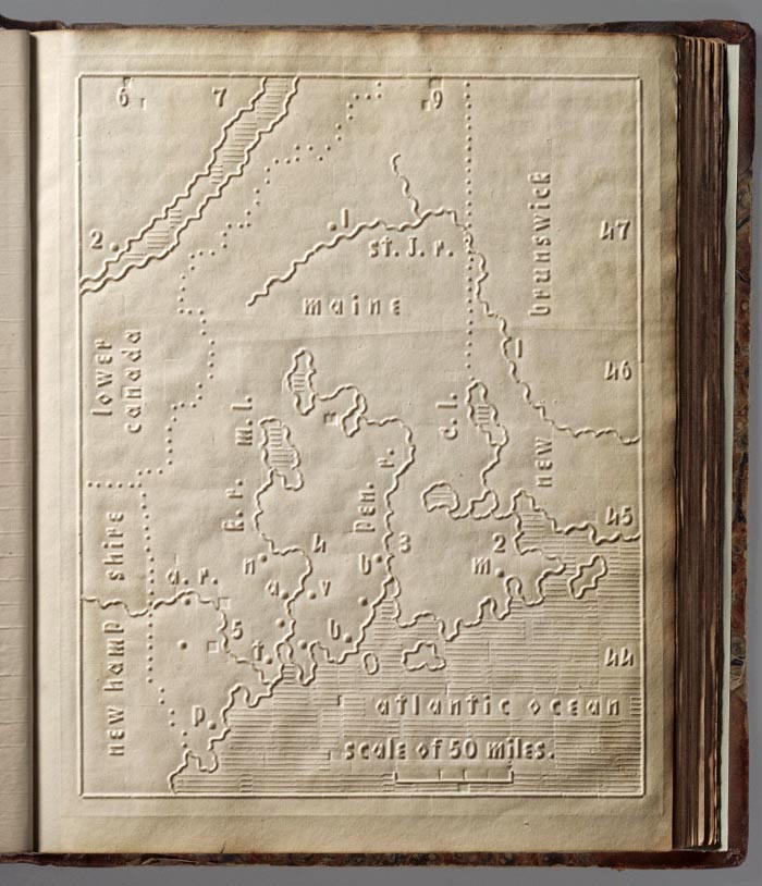
Below is the first map in the atlas, of Maine, with dotted lines showing the border with Canada and New Hampshire. Numbers and letters indicate towns, rivers and lakes, and numbers 6 through 9 and 44 through 47 show longitude from Washington D.C. and latitude. The map shows a scale of 50 miles. All of this and more is explained in the text page for Maine.
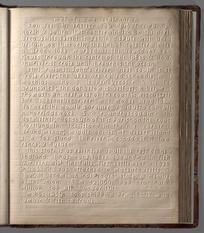
The text page titled "map of maine, explanation" that follows the Maine map: